


Google Earth
Google LLC
I use Google Earth when I want to understand a place spatially rather than simply find its address. That difference is the app’s real strength. It turns the planet into something I can rotate, zoom into, and inspect from several angles, making geography feel less like a list of names and more like a connected landscape. Google LLC’s free Travel & Local app is available to everyone, and its enormous reach—over 500 million installs—makes sense once you see how quickly it can answer questions that ordinary map browsing leaves vague.
My review focuses on one capability in particular: exploring places through a globe-based visual view. This is not just a decorative way to look at maps. In everyday use, the globe helps me understand distance, terrain, coastlines, city layouts, and the relationship between places before I make a travel decision or try to learn something new. It is also why I would choose this app for exploration, while choosing a conventional navigation app when I need turn-by-turn directions.
Why the globe view changes the way I understand places
Most map apps begin with the assumption that I already know what I am looking for. I type a business, street, or destination, and the app gives me a practical route. Google Earth starts from a different question: what is this place actually like, and how does it fit into the surrounding world? I can begin with a continent, move toward a coastline, and then examine a city without losing that wider context.
Related News

Geometry Dash Lite: Enhanced Rhythms with Android and iOS Updates
How Google Earth Redefines Our Global Perspective
PUBG MOBILE Is Built for Patient, Competitive Players
That gradual change of scale is more useful than it may sound. When I look at a destination on a flat map, I can recognize its name but still misunderstand its setting. The globe view makes it easier to notice whether a town sits beside mountains, near a broad river, on an island, or at the edge of a dense urban area. Those relationships can affect a trip, a school project, or simply my sense of direction.
The experience feels especially natural on a phone because I can use touch gestures to move around the planet instead of treating the screen as a static sheet. I can spin the world, zoom toward a region, and keep narrowing the view until the broad geography becomes a local scene. That movement gives me a stronger mental map than jumping directly from a search result to a pin.
Related News

Why WhatsApp Messenger Still Makes Everyday Communication Feel Easy

Jurassic World: The Game Is the Better Dino Tycoon for Strategic Players

Threads in Real Life: Who Should Join, Lurk, or Leave
How SHEIN Turned Shopping Into an Endless Content Feed
How to Make Fortnite Feel Smarter on Mobile

Should You Switch to Microsoft Outlook on Mobile?
I also appreciate that the app is not limited to famous landmarks. Its value often appears in ordinary places: checking how a neighborhood sits against a hillside, seeing how a coastal road follows the shoreline, or comparing the shape of two nearby lakes. The visual context encourages curiosity, and that makes it more engaging than a basic address finder.
What I actually do with it during a normal week
A realistic example is planning a weekend visit to a town I have never seen. I first examine the surrounding region to understand the main roads, nearby water, and larger cities. Then I move closer to the town and look at the layout instead of relying only on a list of attractions. This helps me decide whether a hotel described as “near the center” is likely to feel central, or whether a supposedly short trip crosses a major geographic barrier.
I do not treat the image as a substitute for current local information. Rather, I use it to form better questions. After exploring the area, I may check opening hours, transport details, or recent conditions elsewhere. The app is strongest at showing spatial relationships; it is not the only tool I need for the practical details of a journey.
Gallery
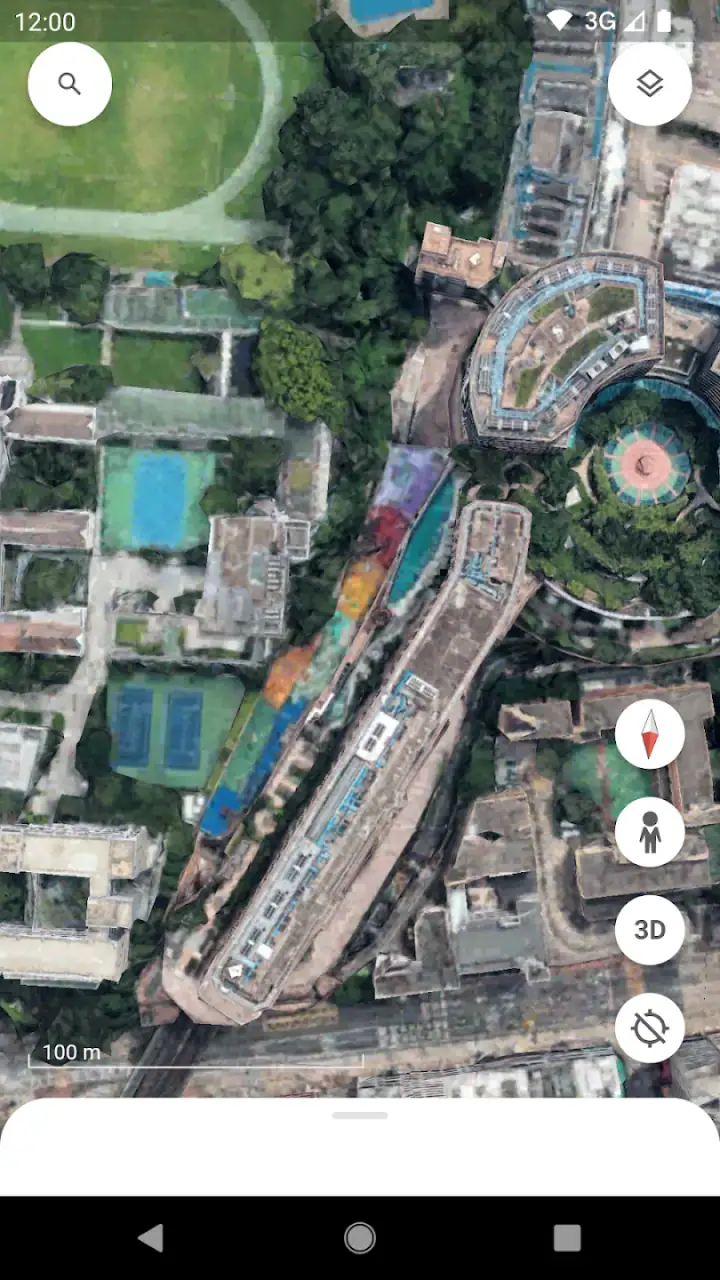
Another useful routine is comparing places before choosing a destination. I can inspect the shape of a coastline, the amount of visible urban development, and the surrounding terrain without opening several unrelated pages. This does not tell me whether a place will match my personal taste, but it gives me a more informed starting point than a few promotional photographs.
For learning, I find the globe particularly effective. A child asking why one city has a different landscape from another can see the answer through location and terrain instead of memorizing a paragraph. Adults can use the same approach to refresh their understanding of countries, islands, mountain ranges, or river systems. The app makes geography exploratory, which is often easier to remember than reading isolated facts.
A practical workflow that avoids the app’s common frustrations
I get better results when I start wide and move inward slowly. If I immediately zoom toward a dense city, I can lose the geographic context that makes the globe useful. Beginning with the region lets me understand orientation first. I then pause at each scale and ask what has changed: the coastline, the road pattern, the terrain, or the concentration of buildings.
It also helps to search with a specific purpose rather than wandering indefinitely. “How is this city positioned?” is a useful goal. “What can I find?” can turn into aimless zooming. When I am comparing two destinations, I use the same viewing scale and look for the same elements in both. That makes the comparison fairer and prevents the more visually dramatic place from automatically seeming better.
One less obvious benefit is that the app can reveal why a route or neighborhood feels different from its description. A place may be geographically close to an attraction but separated by a river, steep terrain, or a large built-up area. I would still verify walking routes with a navigation service, but this visual inspection helps me avoid assuming that distance on a map equals convenience on foot.
I also use the app as a pre-visit orientation tool. Before arriving somewhere unfamiliar, I explore the broad shape of the area and identify recognizable features such as water, major open spaces, or unusual bends in roads. That does not replace local signs, but it reduces the feeling of arriving without any mental picture.
Where this capability is most useful
The best scenario is trip planning before the itinerary becomes too detailed. If I am deciding between two coastal destinations, the globe view helps me understand their surroundings before I spend time comparing individual hotels or attractions. It is useful for checking whether a destination feels isolated, connected to a larger urban area, or positioned near landscapes I want to experience.
It is also excellent for explaining a place to another person. Instead of sending a pin and saying “it is over here,” I can show how the location relates to the rest of the region. That is helpful when discussing a family trip, teaching geography, or helping someone understand why two places that look close in a list may be far apart in practice.
For students, the strongest use is visual investigation. A lesson about islands, deserts, borders, or urban growth becomes more concrete when the learner can move from a global view to a local one. I would not use it as the sole source for a formal assignment, but it is a very good starting point for forming questions and noticing patterns that deserve further research.
There is a quieter use case as well: armchair exploration. When I have a few spare minutes, I can examine a region I know little about and build a rough understanding of its shape. This is more satisfying than scrolling through random images because the experience preserves a sense of place and scale. I can see how one area connects to another rather than viewing destinations as disconnected cards.
The tradeoff between visual discovery and practical navigation
The same design that makes the app engaging can make it less efficient for routine travel tasks. If I already know the exact address of a restaurant and simply need the fastest route, a conventional navigation app is usually the better choice. Google Earth encourages looking around, while navigation tools prioritize arrival. Neither approach is wrong, but they serve different moments.
There can also be friction when I move between scales too quickly. A city may look simple from above and become visually busy when I zoom in. On a phone, small details can require patience, and extended exploration is more comfortable on a larger screen. I find that short sessions work well for orientation, while deep visual browsing can feel tiring if I am trying to complete a practical task.
Another tradeoff is interpretation. A compelling visual view can create a strong impression, but an impression is not the same as current ground truth. Conditions change, buildings are renovated, roads are altered, and a scene viewed from above cannot tell me how welcoming, noisy, accessible, or safe an area feels. I use the app to understand geography, then confirm time-sensitive decisions with more appropriate sources.
It is also possible to overestimate what the globe can answer. It can show me that a destination is surrounded by hills, but it cannot by itself explain the quality of a trail, the difficulty of a climb, or the condition of a road. It can make a city’s layout clear, but it does not replace local transport information. This distinction matters because the app is persuasive visually; I have to resist treating a clear picture as a complete travel guide.
Compared with a standard map application, this one feels more exploratory and less transactional. Compared with travel websites, it gives me stronger geographic context but less emphasis on bookings, reviews, and schedules. Compared with a navigation app, it is better for understanding the destination before leaving and less suitable for guiding me through the final streets. I would happily use it alongside those tools rather than expecting one app to do every job.
Small habits that make exploration more useful
I recommend checking a destination at more than one scale. At the widest level, I look at its position within the country or region. At the middle level, I examine nearby terrain and major connections. At the closest useful level, I inspect the neighborhood pattern. This three-step habit prevents the common mistake of judging a place only by a close-up view.
When comparing accommodation areas, I look beyond the label attached to the listing. I examine the distance to water, parks, central streets, and major roads, then consider whether the apparent route is likely to be direct. I still verify the actual journey elsewhere, but this process helps me spot descriptions that sound similar while representing very different surroundings.
For learning, I ask the user to predict what will appear before zooming in. For example, if a city is beside a mountain range, what might happen to its road pattern or built-up area? That turns passive viewing into an active exercise. It is a simple technique, but it makes the app more valuable for families and classrooms because the learner is interpreting the landscape rather than merely spinning the globe.
I also avoid leaving the app open as background entertainment for too long. Its strongest moments come when I have a question to investigate. A focused search—understanding a coastline, comparing two regions, or preparing for a visit—produces more value than endless movement without a purpose.
Who will get the most from it
This app is a strong fit for curious travelers, students, teachers, families, and anyone who thinks visually. It is especially useful for people who want to understand a destination before choosing where to stay or what to visit. The free price removes an obvious barrier, and the Everyone content rating makes it suitable for shared exploration across age groups.
Its established presence is reflected in an average rating of 3.8 from around three million ratings and roughly 104 thousand written reviews. Those figures suggest a widely used product that people find valuable but not universally perfect. My experience fits that balance: the central globe exploration is compelling, while the app becomes less appropriate when I need highly practical, immediate navigation.
I would recommend skipping it if your only goal is turn-by-turn driving, quick business searches, or current local recommendations. In those situations, a dedicated navigation or local-search tool will usually get you to the answer faster. I would also avoid relying on it alone for accessibility planning, live travel conditions, or detailed outdoor preparation, because visual geography cannot answer every ground-level question.
On the other hand, if you often ask “what is this place really connected to?” or “what will the surroundings be like when I arrive?”, Google Earth earns a place on your phone. It is free, made by Google LLC, and has been available since February 22, 2010, but its age is not the main reason I return to it. I return because the globe view changes the way I think before I travel.
My final recommendation is to treat it as a visual thinking tool rather than a complete travel companion. Start wide, compare locations at the same scale, use it to expose geographic tradeoffs, and then switch to specialized apps for routes, schedules, reviews, and current conditions. Used that way, it does much more than display a planet: it helps me build a reliable mental picture before I make a real-world decision.
FAQs for Google Earth
What features does Google Earth offer?
Google Earth provides a comprehensive view of the planet with high-resolution satellite imagery, 3D terrain, and street views. Users can explore cities, landmarks, and even the ocean floor. The app also offers educational layers, historical imagery, and the ability to create custom maps and tours.
Is Google Earth free to use?
Yes, Google Earth is free to download and use on both Android and iOS devices. While the basic features are available to all users, there may be some advanced tools and data that require a Google account or additional permissions to access.
Can I use Google Earth offline?
Google Earth primarily requires an internet connection to access the latest satellite imagery and updates. However, users can save certain maps and locations for offline viewing, which is useful for areas with limited connectivity, but this feature may have limitations regarding data size and detail.
How accurate is the imagery on Google Earth?
The imagery on Google Earth is generally very accurate, but updates can vary depending on the location. Urban areas tend to have more frequent updates, while remote regions might have older data. Users should be aware that some images may not reflect the most current changes in landscapes or infrastructure.
Is Google Earth the same as Google Maps?
While Google Earth and Google Maps share similar features, they serve different purposes. Google Earth is designed for exploration with 3D imagery and detailed views, while Google Maps focuses on navigation and provides detailed directions and location-based services. Both apps complement each other but cater to different user needs.
Pros
- Stunning satellite imagery and 3D terrain.
- Comprehensive global data coverage.
- Smooth and intuitive navigation.
- Educational layers and tours available.
- Free access with no hidden costs.
Cons
- Requires a stable internet connection.
- Can be demanding on older devices.
- Limited offline functionality.
- Some areas have low-resolution images.
- Occasional data update delays.


